
With the upcoming PECS 2026 conference in Malta, we take the opportunity to revisit one of our key space projects — the development of a star simulator for a Fine Guidance Sensor under ESA PECS Phase 5. This work is part of our ongoing activities in space image simulation and has continued to evolve since its initial delivery, with new developments also described in the accompanying brochure.
SkySim4FGS is a software tool for generating highly realistic synthetic images of the starry sky, designed for testing and development of space optical systems.
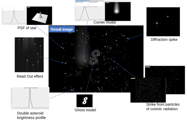
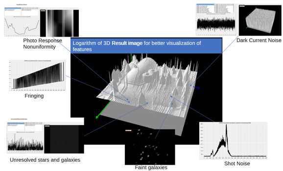
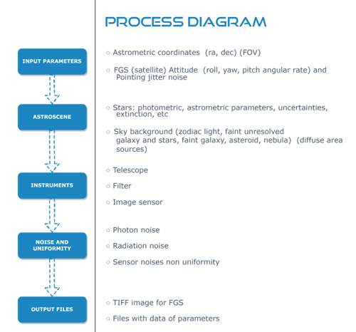
The system simulates how cameras and sensors would observe space under real conditions — taking into account optics, noise, satellite motion, and the surrounding environment.
What SkySim4FGS does
- Generates star field images based on the Gaia DR3 catalogue
- Simulates real-world effects:
- Sensor noise and non-uniformities
- Optical distortions (PSF, blur, distortion)
- Satellite motion and vibrations
- Radiation effects on the sensor
- Enables accurate evaluation of attitude determination algorithm errors
Each synthetic image is accompanied by precise star coordinates, making the system ideal for algorithm validation.
Main modes
- SkySim4FGS - Simulation of a Fine Guidance Sensor operating at the L2 point. Used for testing satellite attitude control systems.
- SkySim4SpaceSST - (In cooperation with Astros, expected February 2027) Simulation of Space Surveillance and Tracking (SST) systems:
- Satellites
- Space debris
- Planets, the Moon, Earth limb
Supports both space-based and ground-based systems.
- SkySim4EarthSST (In cooperation with Astros, expected February 2027) Adds atmospheric effects:
- Seeing
- Refraction
- Light pollution
- SkySim4STR (Expected end of 2027) - Simulation of Star Tracker systems with consideration of:
- Optics
- Radiation
- Parasitic effects (stray light, ghosting, glare)
Future development
The platform will evolve towards even greater realism and automation:
- Use of real camera calibration data
- Improved sensor modelling
- Optimisation using machine learning
- Simulation of complex scenarios:
- Satellite docking
- CubeSat constellations
- Laser inter-satellite communication
- Close-range space debris observation
- Optical degradation due to micrometeoroids
Target users
- FGS and Star Tracker developers
- Companies working with SST systems
- Teams involved in space navigation and image analysis